MAPS OF TERM -I
Maps of Term-1
Subject - History
Chapter-1: The French Revolution
Outline map of France (For locating and labelling/Identification)
- Bordeaux
- Nantes
- Paris
- Marseilles
- Versailles

- Chapter-2: Socialism in Europe and the Russian Revolution
Outline map of World (For locating and labelling/Identification)
- Major countries of First World War: (Central Powers and Allied Powers); Central Powers - Germany, Austria-Hungary, Turkey (Ottoman Empire); Allied Powers - France, England, (Russia), America

- Major countries of First World War: (Central Powers and Allied Powers); Central Powers - Germany, Austria-Hungary, Turkey (Ottoman Empire); Allied Powers - France, England, (Russia), America
- Subject - GeographyCH-1 : INDIA-SIZE AND LOCATIONIndia - States with Capitals, Tropic of Cancer, Standard Meridian, Southern most, northern most, eastern most and western most point of India (Location and Labelling)

 CH-2 : PHYSICAL FEATURES OF INDIA
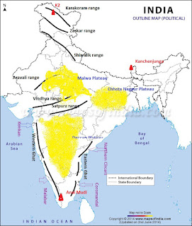
- Mountain Ranges: The Karakoram, The Zasker,The Shivalik, The Aravali, The Vindhya, The Satpura, Western & Eastern Ghats
- Mountain Peaks: K2, Kanchan Junga, Anai Mudi
- Plateau: Deccan Plateau, Chotta Nagpur Plateau, Malwa plateau
- Coastal Plains: Konkan, Malabar, Coromandal & Northern Circar (Location and Labelling)
CH-3 : DRAINAGERivers: (Identification only)- a) The Himalayan River Systems-The Indus, The Ganges, and The Satluj
- b) The Peninsular rivers-The Narmada, The Tapi, The Kaveri, The Krishna, The Godavari,The Mahanadi
Lakes: Wular, Pulicat, Sambhar, Chilika, Vembanad, Kolleru 


Pls subtract some syllabus
ReplyDeleteWho are uu ????
Delete