Posts
List of Map Items CLASS IX
- Get link
- X
- Other Apps
List of Map Items CLASS IX Subject - History Chapter-1: The French Revolution Outline map of France (For locating and labeling/Identification) Bordeaux Nantes Paris Marseilles Chapter-2: Socialism in Europe and the Russian Revolution Outline map of World (For locating and labeling/Identification) Major countries of First World War: (Central Powers and Allied Powers); Central Powers - Germany, Austria-Hungary, Turkey (Ottoman Empire); Allied Powers - France, England, (Russia), America Chapter-3: Nazism and the Rise of Hitler Outline map of World (For locating and labeling/Identification) Major countries of Second World War: Axis Powers – Germany, Italy, Japan; Allied Powers – UK, France, Former USSR, USA Territories under German expansion (Nazi power): Austria, Poland, Czechoslovakia (only Slovakia shown in the map), Denmark, Lithuania, France, Belgium Subject - Geography CH-1 : INDIA-SIZE AND LOCATION India - States with Ca...
IÑĎIÃ.......WITH 70 NOT OUT ON THE WAY TO PROGRESS.....
- Get link
- X
- Other Apps
Assignment of THE FRENCH REVOLUTION ( for revision)
- Get link
- X
- Other Apps
SECTION -1 Q-1 How was the French society divided before revolution? Ans - 1) First estate- It consisted clergy. They had not to pay any tax. They enjoyed privileges by birth. 2) Second estate- It consisted nobles and rich people. They also had not to pay any tax. Had privileges by birth. 3) Third estate-It consisted other people of the society.They had no rights and had to pay all the taxes to king and church both. Q-2 What were the causes of the French revolution? Ans-1) Long years of wars made the finance of the country empty. 2) The third estate was highly discriminated by the king, nobles and church. 3) All the taxes were paid by the third estate. 4) Bad harvest created shortage of food among the people. 5) The growing middle influenced the people to get equality and freedom. 6) The prices of bread were increased and wages were less. 7) The increased prices and wages could not make balance. Q-3 Give reasons for subsistence crisis in France during old regime? Or Q...
Maps for half yearly exams (geography)
- Get link
- X
- Other Apps
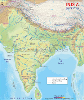
Chapter-1: INDIA-SIZE AND LOCATION India -States with Capitals, Tropic of Cancer, Standard Meridian, Southern most, northen most, eastern most and western most point of India (location and labelling) Chapter-2: PHYSICAL FEATURES OF INDIA Mountain Ranges: The Karakoram, The Zasker, The Shivalik, The Aravali, The Vindhya, The Satpura, Western & Eastern Ghat. Mountain Peaks – K2, Kanchanchunga, Anai Mudi, Plateau – Deccan Plateau, Chotta Nagpur Plateau, Malwa plateau Coastal Plains – Konkan, Malabar, Coromandal & Northern Circar (Location and Labeling) Chapter-3: Drainage Rivers: ( Identification only ) The Himalayan River Systems – The Indus, The Ganges, and The Satluj The Peninsular rivers – The Narmada, The Tapi, The Kaveri, The Krishna, The Godavari, The Mahanadi Lakes: Wular, Pulicat, Sambhar, Chilika, Vembanad The extreme point to India to four sides East West North South are as below- South...